


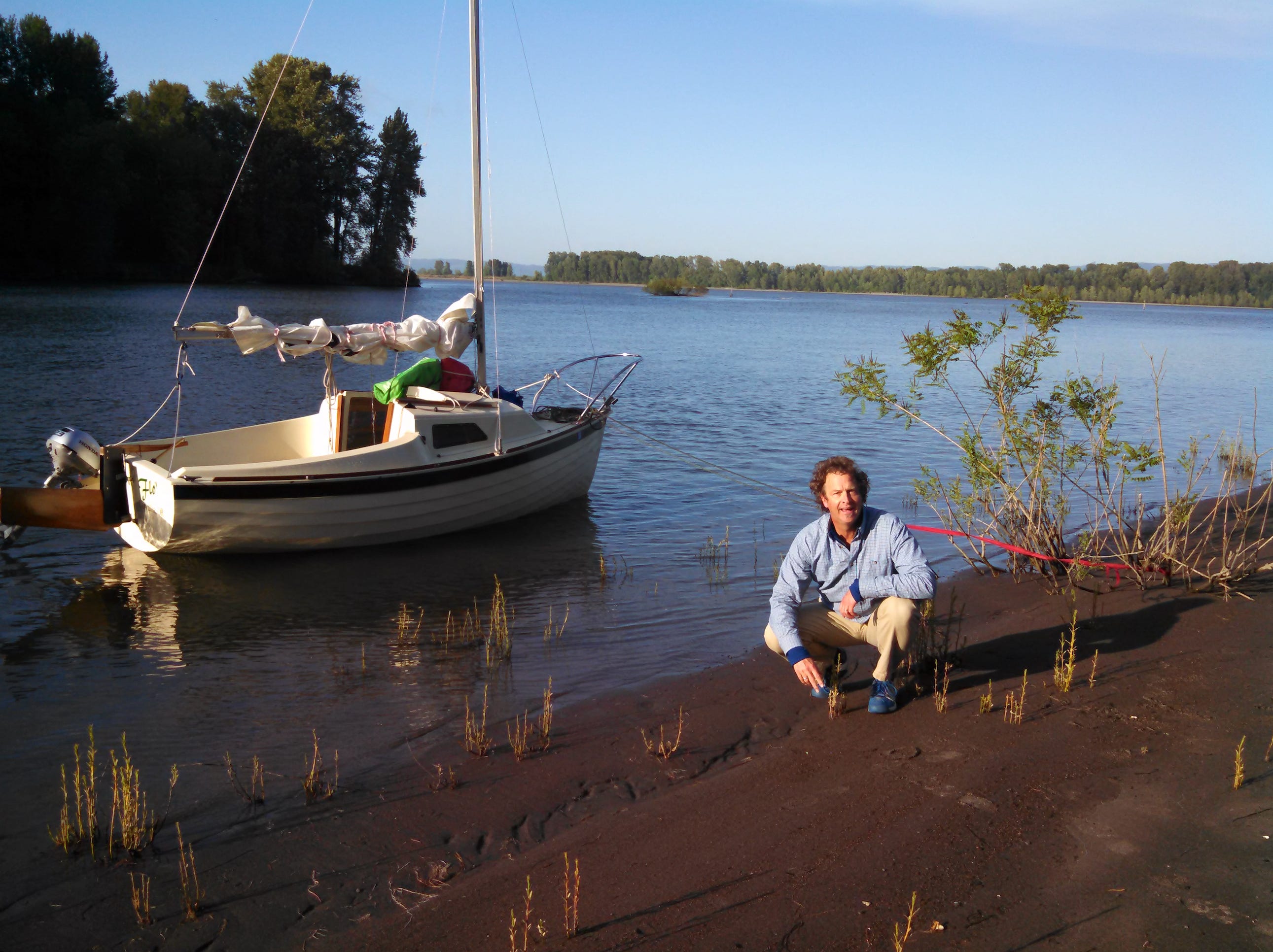
The Lower Columbia in "Flo’"
We had little idea that what we were doing would be very difficult to repeat.
By Jim Phelps
Sometimes you find out later how lucky you were. When sailing, this sometimes happens when you try to replicate a previous great trip and discover that everything is not as easy the second time. On our first Columbia River trip, my friend Rick and I were very fortunate. At the time, while enjoying ourselves tremendously, we had little idea that what we were doing would be very difficult to repeat. On a second trip several months later, I found out.
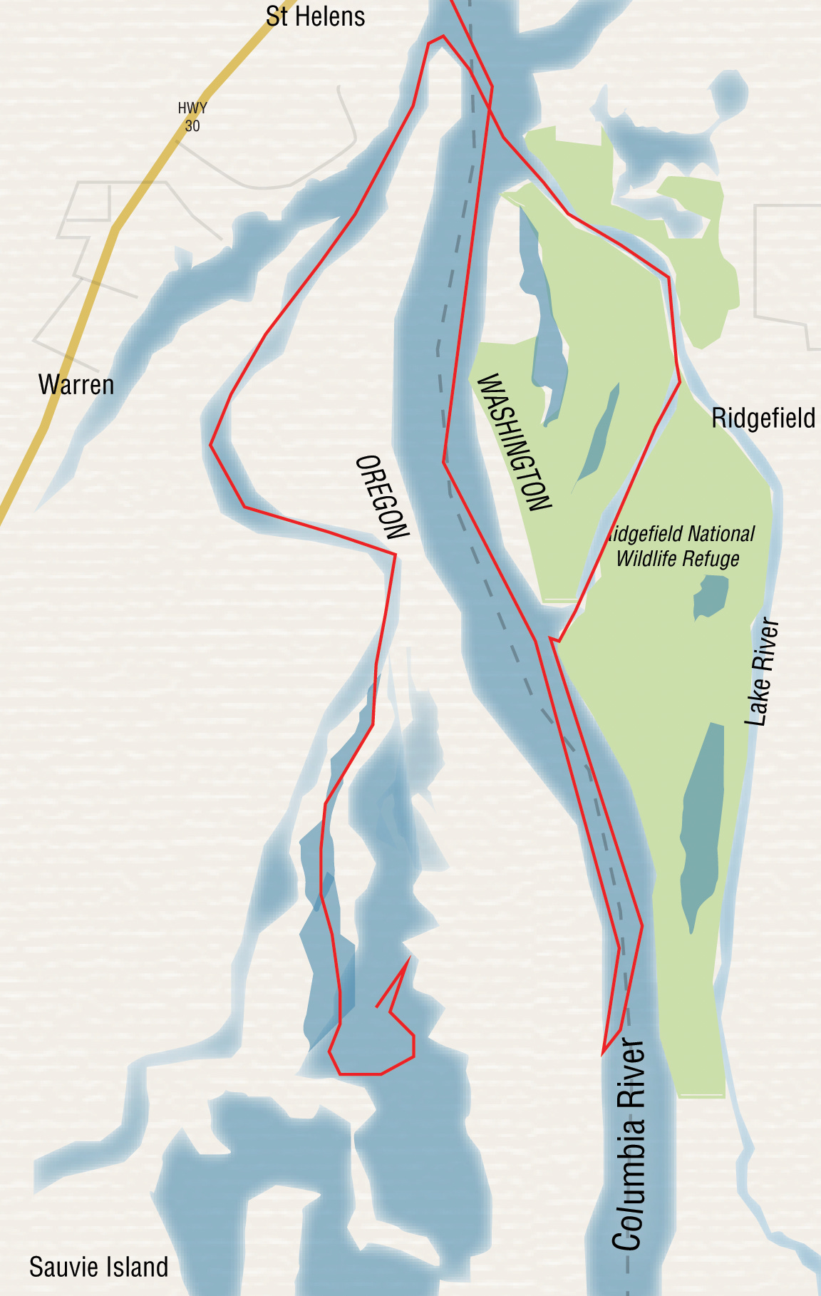
Studying the maps beforehand (always part of the fun), a sail on the lower Columbia River around St. Helens looked like a reasonable bite to chew in three days, with good back-up alternatives. As it turned out, we were on Plan A all the way. We launched from a small ramp in waterfront St. Helens, just below Sauvie Island on the Oregon side and Ridgefield National Wildlife Preserve on the Washington side. We intended to head south, up one of three arms of water that converge just upstream from St. Helens: the Columbia, the Ridgefield Channel, and the Multnomah Channel (the latter borders Sauvie Island on the west, if you’ve got your map out now).
This was my first time overnighting in Flo’ (note the apostrophe for the requisite additional entendre). She’s a Montgomery 15 acquired after careful study of months of Small Craft Advisor issues. Whitewater kayaking and canoeing have made me comfortable with current, but if we’d had less wind, we’d not have been able to sail upriver against the early spring flow of the Columbia. With a steady north wind about 15 knots, at one point we were actually surfing a small wave train just off the light at the north end of Sauvie Island. To make better progress upstream we ferried over and went up the Washington side. Flo’’s 15-inch draft, board up, allowed us to work in close to shore where the current was much diminished. Overall we were making 3-4 knots (about 2 knots over ground on average) for several hours.
We passed the mouth of Bachelor Slough, which heads east into the Ridgefield Wildlife area. The point of land at its junction with the Columbia looked good for camping but daylight remained, so we pressed on upriver and explored another potential mooring site, at the inlet alongside Reeder Road on Sauvie Island. Surprisingly, a rope hung across the mouth of this finger of the Columbia and a sign forbade anchorage. Well, thanks very much for the welcome, folks. We beat back down the Columbia to the entrance to Bachelor. This was another stroke of good fortune as we enjoyed a lovely campsite and beautiful waning light, in the company of hordes of purple martins (a large swallow, living in many houses hung for them around the refuge).
Dropping the hook required some thought. Bachelor Slough is actually an arm of the Columbia flowing off gently to the east and rejoining down by St. Helens. So we were anchoring in current, but needed to contend with occasional large waves coming in off the Columbia from barge traffic. We ended up with a tether arrangement: an anchor out to port and a tie-off to shore to starboard. To offload gear we’d pay out to port and reel in to starboard, then reverse to put her out in water deep enough to handle the barge waves. Trying to replicate this trip in mid-June revealed how lucky I’d been with the first overnight. In the lower summer depths there was much more pronounced wave action from the barges, requiring anchoring out at the length of my shore line, tied to a deadman buried at the high water mark. Even with that maneuver the ride overnight in June was rough. Next time I’d hide behind a small island across the way for protection from those wakes.
After breakfast we walked up to see if Flo’ could fit under a low bridge over Bachelor Slough with her mast up—something you just can’t tell from Google Earth! Nor, it turned out, could we tell by standing on the bridge: it was going to be extremely close. (We did not want to have the experience shown in a YouTube video only months later, the salutary tale of a sailboat lodged under the bridge at Ballard Locks in Seattle). A tidal factor, even 70 miles inland, also needed accounting, but despite studying the tables we were uncertain of how it would affect flow and depth in this side channel. Fortunately, a gentle flow and wind were against us as we approached the bridge, allowing us to approach under twin canoe paddles and hover at the lower edge of the bridge, staring up. Almost?
Flo’ did not like Rick hanging his weight overboard while holding the base of her mast, canting her 30 degrees to starboard. We decided this arrangement was too unstable to count on while paddling or motoring ahead (unlike the stable water-bag arrangement shown on big-boat YouTube videos; e.g. see the 80 foot mast and 60 foot bridge account). So we backed off, removed sail, and prepared to lower the mast. Rick would serve as temporary mast crutch while we motored past the bridge. I’d never done this “at sea” before, only on the hard, but fortunately luck was with us again as we figured out just in time that having a topping lift and boom attached adds a lot of leverage! I shudder to think of the likely outcome had we gone just a few more degrees off vertical before realizing what was adding all that pull on the forestay in my hands. While of course I’m embarrassed to acknowledge this error, perhaps it will help someone avoid disaster if he or she is not sailing with the same angel we had aboard.

Onward, then, relieved and under sail. The winds were just strong enough to enable running a few miles up the Lake River. This oddly named slough drains Vancouver Lake into the Columbia, but flow is minimal, strongly affected by tides. After a nice lunch tied up to shore, we short-tacked back toward the Columbia, retracing our path through Ridgefield where houseboats occupy half the width of the slowly widening channel. Earlier we’d slipped through quietly going downwind/upstream, although we seemed to evoke some surprise among the residents on their porches: they appeared unfamiliar with sailcraft heading upstream. But returning, still under sail and now going to weather, we probably alarmed some residents by heading straight for their living room at four knots before a quick turn through the wind. There wasn’t enough room for any less alarming approach, short of dropping sail and motoring by, and where’s the fun in that? Hopefully our smiles and waves excused our presumptuous use of their front yards.
From the mouth of the Lake River, a bouncy close reach took us across the Columbia to round the north end of Sauvie Island and turn downwind again, up the Multnomah ship channel. I’d hoped for our next destination we might sail all the way up into Sturgeon Lake, in the middle of Sauvie Island. I’d been there once by kayak, and heard from fishermen that it is extremely shallow, so whether we’d be able to sail in it was uncertain, but it’s a beautiful, isolated body of water. Again luck was with us as we’d just enough breeze to wind our way up the Gilbert River, which flows lazily out of Sturgeon Lake. If you’ve looked at Google Maps you’ll have seen that the Gilbert is quite sinuous, but on a lovely warm day we managed the length of it under sail, with an occasional couple of paddle strokes to get us to the next patch of wind. I love the challenge of using any moving air, coming from anywhere, to make a boat progress, so while Rick sang (no one around to care, or so we thought until we bemused a fisherman: he must have wondered what the heck was coming his way) we made our way, finally emerging into a broad lake occupying nearly the entire breadth of Sauvie Island.
No one there. Wonderful. We watched eagles harass osprey; we watched fish leaping; and we gawked at the two volcanoes framed by lobes of the lake: stumpy Mount St. Helens to the northeast and taller, sharper Hood to the southeast, both still very white in April snow garb, turning peach in the setting sun.
With centerboard still up, to be cautious, we beat up to the north end of the Lake looking for a campsite. Another wonderful leg, with Rick enjoying the helm as finally we had room to tack at more leisurely intervals, this showed well that the Montgomery 15 goes fine to windward sans centerboard, just her short keel quite sufficient.
Finding another lovely campsite with a clear view of sunset on both mountains, we anchored Flo’ in about four feet of water and hauled her in with a stern line to offload stove and chairs (and Rick’s sleeping bag: he was camping out, leaving me the pleasure of Flo’s little cabin). Our moorage arrangement again proved lucky (I wish I could say I planned this) as by the following morning, the tide was out and the lake had dropped about 18 inches. Right: the tidal effect extends even up into a lake 80 miles from the ocean. Who’dathunkit.
Leaving the centerboard up was shown to be the right move the following day as we enjoyed a swim in the middle of the lake. After lowering ourselves in, we found that it was only about 5 feet deep, just enough for Flo’s long rudder. More luck: even though I’d arranged a rope-and-plastic-rung swim ladder, we had difficulty ascending it. Good thing I’d read about (and tried, once) using the lazy jibsheet as a stirrup, or we’d have had a time of it, trying to get back aboard. I suppose I could have leapt from Rick’s shoulders as he stood on the bottom! Another embarrassing admission: a brand new swim ladder came with the boat when I bought her. But I’ve not installed it. Something about ruining the lines of such a beautiful hull? Or is it just the thought of someone (ain’t gonna be me) having to wiggle back into that tiny space under the cockpit to put in the faceplates? I’ve since read a Small Craft Advisor note about affixing protrusions to the rudder to serve as steps. Need to do something to make re-entry more secure.

We used Flo’s little 2.3 Honda again to get back out into the Multnomah Channel, but then enjoyed a lively beat down to St. Helens and an uneventful take-out. However, a few months later, the same upstream wind on the Columbia produced steep wind-against-current waves just above St. Helens. I wonder if that might be a result of shallower water in the summer. In any case, in those steep waves, even under reefed main and doused jib Flo’ drove her bow in so deeply that her anchor was lifted right up out of its sleeve high up on the bow pulpit. It was a thrilling experience sitting up on the bow recovering the anchor as we splashed forward. Fortunately I’d tied in the anchor up on the pulpit with just enough slack that the swinging anchor did not bang against the hull. More luck. Note to self: Next time, tie not just up to the pulpit but down to the cleat with a turn around the anchor to keep it in the sleeve. Flo’s accompanying angel was still with us on that second trip, evidently.
“I’d rather be lucky than good” is sometimes attributed to Lefty Gomez, who played for the Yankees in the 1930s. But also to Napoleon: “I do not want a good General, I want a lucky one.” Obviously I’m fortunate to have acquired a lucky boat. Now I can work toward golfer Gary Player’s version of the quote: “The more I practice, the luckier I get.”
•SCA•
Jim Phelps is a psychiatrist in Corvallis, OR. He’s happiest sailing upstream or in narrow quarters. Some sort of pathology reflecting former whitewater paddling, perhaps.
As first appeared in issue #93
I wanted to respond to this article but then remembered the author is a psychiatrist who would certainly ask, "do you want to know why you said that?" And I won't know why..oh well....take a risk.
What a wonderful trip testing skills and enhancing one's seamanship. Seeing areas not often seen by sailors. Great trip.
Grand adventure in your well thought out M15 - congrats