


Small-Boat Cruise Planning Tools
Taking an imagery-based approach with these tools allows me to visualize coves before I enter them, scout trails before walking them, and see photosphere images that inspire me to leave the dock...
Article by Sean Grealish
When planning a route to cruise on my family’s Haven 12 ½ Lazydog, I often find myself wanting more than a simple marine chart. With myriad cruising guides of various vintages, and now internet blog posts which may also be out of date, I turn to two resources I believe are underrated by small boat cruisers: Google Maps, and Caltopo.
Google Maps is useful for more than just street-based navigation. The satellite images are updated every few years in my local waters around Bellingham, WA, and the resolution gives enough detail to examine a cove that may be woefully hard to see on a classical chart. Below is an example showcasing Vendovi Island. Privately owned by the local land trust, it’s only accessible during daylight hours and features some lovely hiking trails and a small dock behind a breakwater at the northern end.

When interfacing with Google maps on a computer, the satellite imagery can be toggled in the lower left corner. You can also turn on street view imagery by clicking the little yellow figure in the lower right corner. If we zoom in on the island we can now take a closer look at the northern cove and can also see that several photospheres are present on the island (click on the blue dots to see the image at that location).

Photospheres are typically submitted by individual users, and their coverage out in island chains can sometimes be sparse, but in the San Juan Islands there are very few islands that don’t have at least one photosphere. Below is the southern photosphere on Vendovi that shows the view off a bluffside trail.

Aside from providing great inspiration to visit a beautiful location, photospheres can also be a planning tool. In my case I was wondering if there was enough room inside the northern cove to sail Lazydog into the dock, or if I needed to plan on dropping my sails outside the breakwater. Luckily for me there is a photosphere right on the breakwater and it’s clear that the cove has plenty of room to sail in.

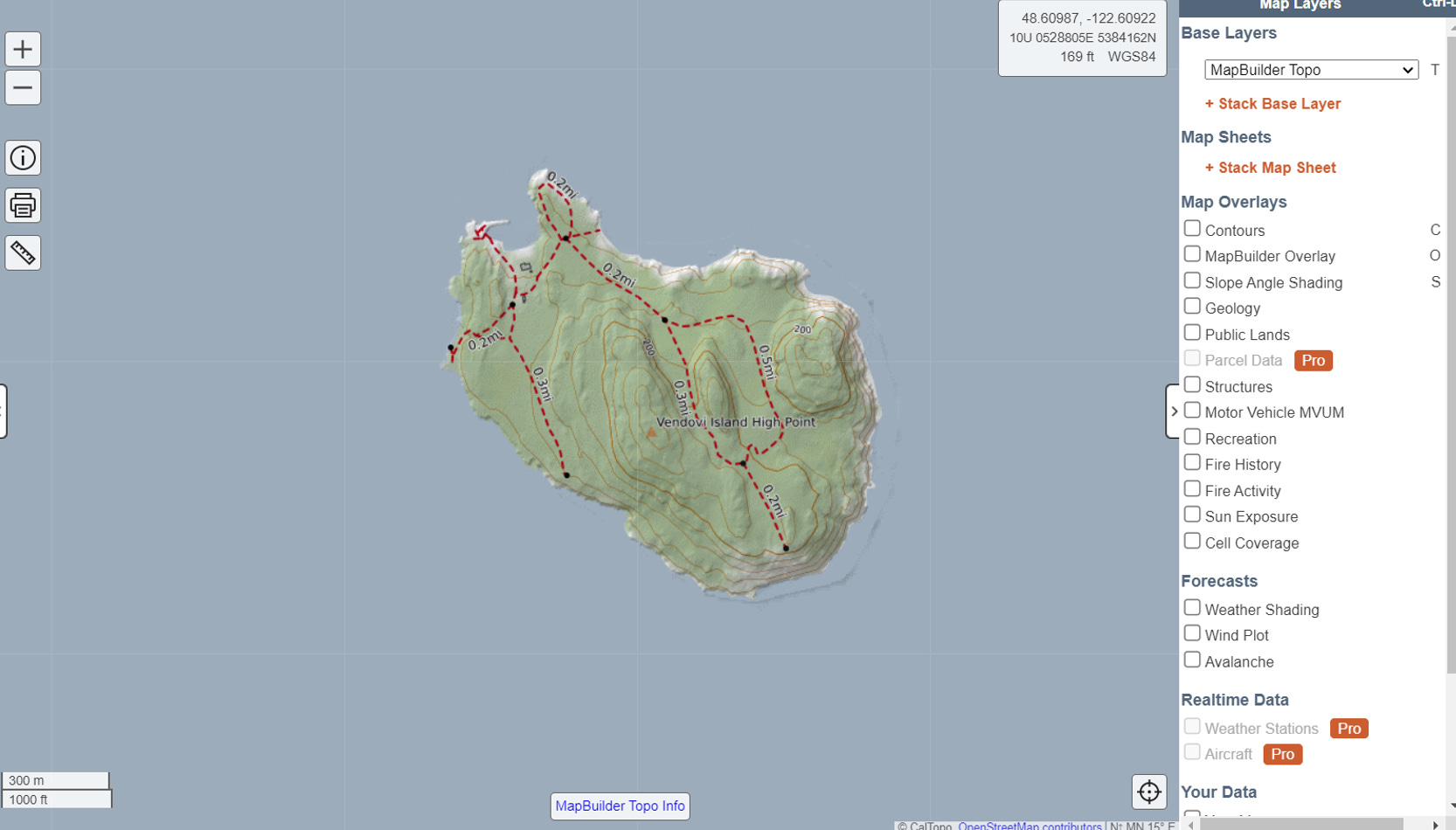
Another free online resource I think is criminally unknown within the sail-and-row community is the website Caltopo. The interface offers an incredible amount of functionality, with zoom, print, and measure tools on the left and a multitude of layers and overlays on the right. You could write an entire book about Caltopo functions, but I’m going to focus only on the map base layers here. The default map (MapBuilder Topo) shown below, has topographic contours as well as hiking trails. In fact you can see that the viewpoint where the bluff view photosphere above was taken is down a 0.3 mile long trail from the dock, and that there are numerous other trails around the island to enjoy.
Caltopo also has a satellite layer (Global Imagery) which isn’t quite as high-resolution as Google maps, but is nevertheless helpful. I often use the stack base layer function to display multiple base layers at the same time and adjust their transparencies to get a combined view.

Last but not least, Caltopo also has a Marine Charts layer, which doesn’t always have a high level of detail but is still a wonderful addition to an already helpful website. Toggling between marine charts, satellite imagery and accurate hiking trail maps on Caltopo takes the multi-computer tab or table of scattered guide books-chaos out of trip planning by putting everything in one place where direct comparison between layers is made simple.

As the users of small boats for camping and cruising we are often caught in a liminal planning space. Stuck between the big boat cruising guides which will overlook a small sandy cove, and the minimalist kayaker guides which may recommend exposed shores since their boats are hauled out overnight. I find Google Maps and Caltopo to be incredibly useful. For folks like me who must plan and examine their entire route before setting off, taking an imagery-based approach with these tools allows me to visualize coves before I enter them, scout trails before walking them, and see photosphere images that inspire me to leave the dock as soon as possible. •SCA•
This is an exceptionally useful article - many thanks!