


At First Everything Was Fine
Sailors encounter challenging weather aboard their 17-foot sailboat
Article by Jeremy Armao • Illustration Rick Myers
It was a perfect Sunday morning last October when my sailing partner, Ernie Brown, and I sailed out of Charleston Harbor, destination: Jekyll Island—150 miles south along the Georgia coast. We elected to take my boat this year, a Sage 17 that I’d bought used last winter with Ernie’s help scanning the want ads.
The first four days were glorious, sunny and warm with winds at about ten knots. We sailed, fished, swam, ate, and slept on the boat. On Monday evening we sailed into the marina at Hilton Head and had dinner with our wives at the Salty Dog Cafe. Early in the trip Ernie mentioned something about bad weather predicted for Thursday, but being one who lives in the moment, I decided not to worry about Thursday till it got here. So it was that we found ourselves anchored in St. Catherines Sound on Wednesday night planning our Thursday sail.
Our original plan had been to anchor in Sapelo Sound on Wednesday night, leaving us about 45 miles to sail on our last day. The winds had been light on Wednesday and died in the afternoon, so we only made it to St. Catherines Sound instead. By our shortest estimate we had 54 miles to sail to the southern tip of Jekyll Island and a few miles after that to get to the boat ramp. We knew there were small craft advisories issued for Thursday, so we considered our options carefully. The wind was forecast to be 20-25 mph out of the north/northeast putting us on a run all day. Even though the greatest distance we had sailed in a single day was 45 miles, we felt that with the forecast wind we could easily average 6 mph and could cover 54 miles in a minimum of nine hours.
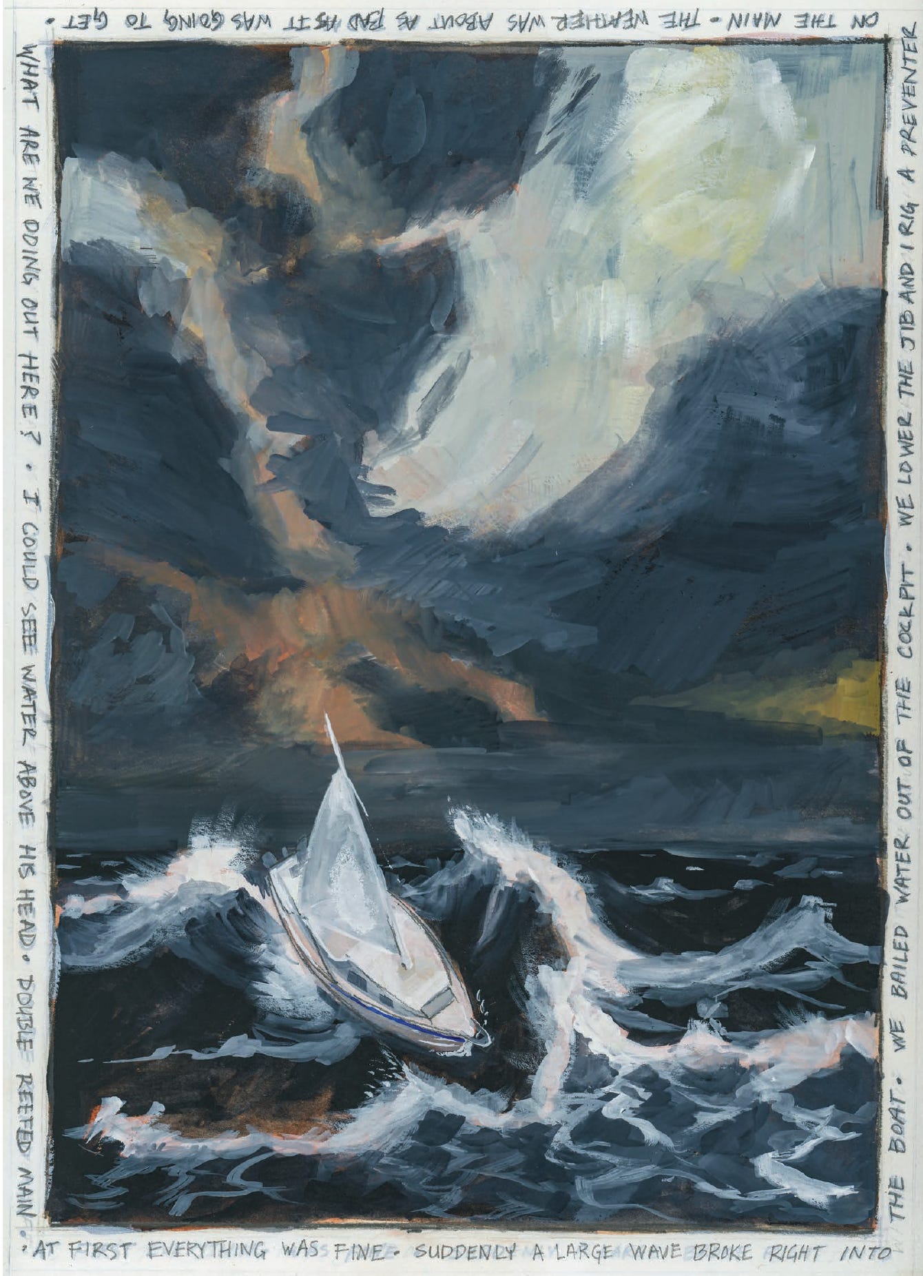
These were best case scenarios obviously. The real question was what the waves would be like. I had been out in 5-6 foot seas in these waters months earlier in the wake of hurricane Alberto off Amelia Island. The boat handled perfectly well on all points of sail. The ride was rough and I got seasick but we were never in any danger. The app that I used to predict conditions (tides4fishing) was calling for 1-2 foot waves at daybreak. Seas would start building by 10 a.m. and max out at 9 feet by 2 p.m. Ernie was using a sailing-specific app (Sailflow) that said seas would not exceed 2 feet. That did not make much sense. He hoped the truth would be somewhere in between, maybe 6-7 feet? I thought the waves might be 9 feet but wasn’t seriously concerned about it because the boat had handled 6-foot waves just fine and I am one to always push the envelope in order to learn. We hoped to be approaching the inlet at Jekyll Island at about the time the waves reached their peak. If it got really rough we’d only have to be out in it an hour or two. Sunrise was at around 7 a.m. but we decided to sail an hour earlier to get ahead of the wind if we could.
I thought the waves might be 9 feet but wasn’t seriously concerned about it because the boat had handled 6-foot waves just fine and I am one to always push the envelope in order to learn.
We discussed possible bail-out scenarios. There were seven estuaries we could duck into in case of emergency or panic. We agreed that we would both wear our inflatable life jackets. We talked about not playing the hero to impress the other. If at any time either of us was petrified we would say so and sail to safety. The air temp was 70 and the water temp 82, so cold was not a factor. Ernie did briefly mention the Intracoastal Waterway north of Jekyll Island but we never really looked at it. We should have, because in hindsight that would definitely have been the way to go. We discussed boat prep and decided to double reef the main and hank on the jib before bed. We had sailed with full main and genoa all week. With the boat as ready as possible and what we thought was a good plan we went to bed early.
We slept well and were up at five a.m. going through our morning routine. I boiled water for coffee in the cabin and Ernie made breakfast in the cockpit. We tidied up, used the port-o-pot and were ready to go. We pulled the anchor promptly at six. The winds were light and we ghosted out of St. Catherines Sound headed just south of east reaching on the light north wind. We had to go straight out four miles to a green buoy in order to clear shallows on the right. We made 3-4 mph, navigating by our phone in the dark first hour. By 7:00 the sky was getting light and we decided to turn south inside the buoy and cut about a mile off the route. The wind was picking up some but the seas were still 1-2 feet and we ran under main and jib. Our speed picked up to 5.5 mph so we were closer to our target speed.
By 8:00 the wind was picking up significantly, with seas up to 3-4 feet. We both put our inflatable life jackets on. We lowered the jib and I rigged a preventer on the main. The sail was on the right side of the boat and we were taking the waves on the left rear (port quarter). Our speed picked up to 7-8 mph. I was happy with this because it meant our average speed would increase to 6 mph. Aside from the normal numb tiller feel of running before the wind, all was well. When running before the wind (going the same direction the wind is blowing) the water passes under the boat backwards from stern to bow. The water is moving faster than the boat. This makes the rudder feel numb and it is difficult to keep the boat moving in a straight line. Ernie and I took our normal one-hour shifts at the tiller. The off man navigates, trims sails, or rests. It becomes work to keep the boat going straight. Every time a wave overtakes the boat it slews the stern to the right and after the wave passes the helmsman has to steer hard back to the right to straighten the boat back out. The wind continued to build and so did the waves. It was tense but we still had control of the boat.
Our speed stayed at 7-8 mph but we started to surf down the front of the overtaking waves a little bit. We hoped it wouldn’t get much worse. We saw only two other boats all day, one fishing boat and one freighter; no small boats and no sailboats.
We passed St. Catherines Island and Sapelo Sound and just south of Sapelo Sound we had our first scare.
Fifteen miles in at 9 a.m., Ernie was at the helm and we sailed over a very small shallow area. The navigation app showed 6 feet of water which we thought was plenty. The boat draws 3'6" with the centerboard down and the app had proven to be exceptionally accurate. We’d sailed over larger areas of shallower water many times in the previous four days. I think the waves must have been running 5-6 feet. Suddenly a large wave broke right into the boat! Ernie and I both got wet and the cockpit was awash. The boat really wasn’t upset but I couldn’t quite figure out what had happened. Maybe the waves were reaching a point where they were going to start breaking into the boat regularly? I was scared. I’m not sure I had ever felt like I was in over my head in my life but I felt like maybe I was just then. What are we doing out here? I thought. All I knew was that I didn’t want that to happen again. I don’t know what Ernie was thinking but I was struggling to make sense of our situation. No other wave broke into the boat. We bailed the water out and kept going for lack of anything else to do. We finally came to the realization that shallow water was the culprit. In deep water waves are just big humps of water. The boat rides over and around them without trouble, but in shallow water the bottom of the wave hits the sand and the top breaks over. This is why waves break on the beach. It’s not that complicated to figure out but we couldn’t process the fact that this could happen three miles offshore. We vowed to avoid shallow water at all costs.
Keep reading with a 7-day free trial
Subscribe to Small Craft Advisor to keep reading this post and get 7 days of free access to the full post archives.